Without positive planning supporting some new development, current projections suggest that the population of Swaledale will continue to decline and get older, with a resulting loss of services, jobs, and community sustainability.
A target of 4-5 new dwellings per year in Swaledale and Arkengarthdale would bring enough people into the area to cancel out the natural outflow. Any less and the decline would continue. A few more would bring more services to the area, but might be an unrealistic target.
This is the conclusion in the thinking behind the new local plan being produced by Yorkshire Dales National Park, that will be used to shape development decisions for the next twenty years or so. The plan is work in progress and is currently open for public consultation, and we are being asked to contribute our views on how much new housing is needed, what type of housing it should be (size, tenure) and where it should go. To help us, the Park has produced some maps and documents and there are some links below. We can help by sharing our views, and in particular, by putting forward suggestions of land that could be used for new housing.
This is the third consultation for the current plan, and the Park has already learnt that people want new development to shift focus towards smaller houses and flats. You can add your views on this, and also on affordable housing and open spaces.
In the existing local plan, Reeth is identified as a ‘service settlement’, essentially a hub for Swaledale with a range of services (shops, health centres, pubs etc), a status it shares with Grassington, Hawes, and Sedburgh for their dales. But in the proposed new plan, Reeth is re-categorised as a ‘larger village’ just like Grinton, Gunnerside, Hudswell, Langthwaite, Low Row and Muker. This means that questions about development for the remaining three Dales’ service settlements (or ‘towns’ as they are now labelled) aren’t being considered for Reeth. Specifically, the thoughts are that Grassington, Hawes and Sedbergh are ‘the most sustainable places for planned housing and employment growth, and to accommodate new community services’. Reeth is no longer in this list. Nowhere in Swaledale or Arkengarthdale is in this list.
This change of status isn’t down to evil scheming on the part of the Park planners, it reflects the fact that Reeth is smaller than Grassington, Hawes and Sedbergh, and its viability as the ‘capital of Swaledale’ has always been borderline. The Park is keen to point out that the distinction doesn’t mean that planning applications for Reeth will necessarily be treated differently, and is anyway academic unless new development sites become available for consideration.
But it does present a challenge to think about how Swaledale and Arkengarthdale should work in the future. If you want Reeth to have a future as a hub for our two dales, most of those extra 4-5 houses per year will need to be in Reeth and now is the time to tell the Park. Likewise, if you’d prefer to see those houses distributed more evenly around the two dales, or not built at all, and you’re happy to accept the loss of services these two choices would mean, have your say.
Of course, the Park has no magic housing tree, and development will only happen if there are sites available. So the consultation also contains a ‘call for sites’: aimed at landowners or communities to put forward sites that are suitable, available and achievable.
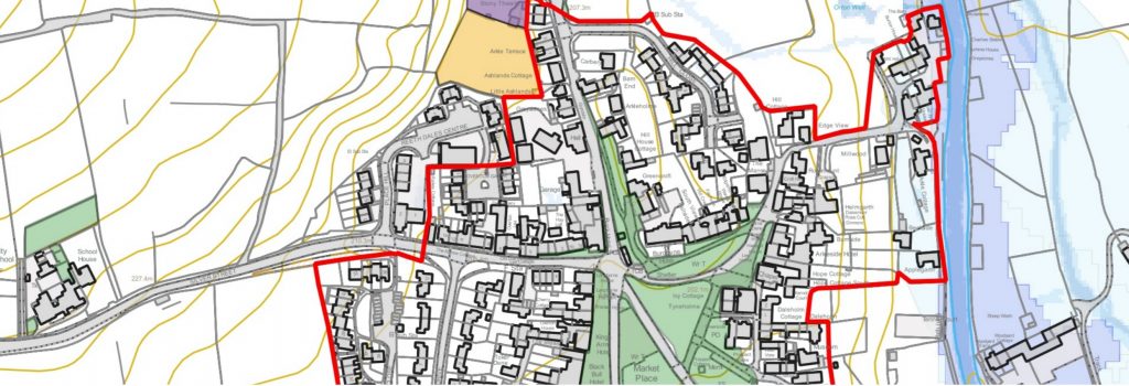
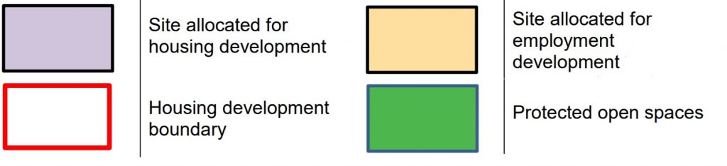
A good place to start is by looking at the maps for our larger villages (including Reeth) to think about their boundaries and the potential for development with them. Here is a key and links to the relevant maps:
Grinton: https://www.yorkshiredales.org.uk/wp-content/uploads/sites/13/2020/12/Grinton.pdf
Gunnerside: https://www.yorkshiredales.org.uk/wp-content/uploads/sites/13/2020/12/Gunnerside.pdf
Hudswell: https://www.yorkshiredales.org.uk/wp-content/uploads/sites/13/2020/12/Hudswell.pdf
Langthwaite: https://www.yorkshiredales.org.uk/wp-content/uploads/sites/13/2020/12/Langthwaite.pdf
Low Row: https://www.yorkshiredales.org.uk/wp-content/uploads/sites/13/2020/12/Low-Row-Feetham.pdf
Muker: https://www.yorkshiredales.org.uk/wp-content/uploads/sites/13/2020/12/Muker.pdf
Reeth: https://www.yorkshiredales.org.uk/wp-content/uploads/sites/13/2020/12/Reeth.pdf
The full consultation document (which contains useful background information), and the response and ‘call for sites’ form are available here: https://www.yorkshiredales.org.uk/park-authority/living-and-working/planning-policy/local-plan-2023-40/consultation-no-3-exploring-our-options-building-new-homes/
If there are open spaces within the marked boundaries on the maps that you think should be protected (or are shown as protected but shouldn’t be) you can comment on these. There is also a call for infrastructure suggestions and for projects that are clearly beneficial development but require planning permission. As an example (and that’s all it is), upgrading the footpath between Reeth and Grinton to an all-weather bridlepath might help Reeth extend its critical mass by binding the two settlements more closely together, reduce car journeys and provide an extension to the Swale Trail.
Remember that planning isn’t about allocating funds, it’s about setting guidelines for what new development takes place and where it goes. The deadline for responses is 26th February.